![]()
| Switzerland/France/Italy | Tour du Mont Blanc | 2000.07.10 - 07.23 |
Tour du Mont Blanc (TMB), Part 2
Updates based on our TMB hike in August 2001 are added in Orange.
Read all the helpful TMB
introductory information on "Tour du Mont
Blanc (TMB), Part 1" page if you haven't already done so.
Key used for lodging:
B = breakfast;
L = lunch;
D = dinner
V = Visa credit card accepted;
MC = Master Card credit card accepted
CHF = Swiss Franc; FRF = French Franc; ITL = Italian Lira
Days 6 & 7: Chamonix (France), yet more rest days
Today is the third consecutive rain day, and the fourth day of Wes' cold. We decided to buy Wes some cold & flu medicine.
Cold weather moved in. The Alps experienced winter conditions in the middle of July. The snow level fell to 1800 M / 5900 ft and strong gusts of wind forced closure of gondolas. The weather forecast predicted continued poor conditions so we decided to escape to Annecy for 2 days.
Day 10: Chamonix (France)
Chamonix was just as we left it - rain. But at least the forecast predicted sun in 2 days. We found much better accommodation in Chamonix this time around.
After practicing patience for a full week, we got better at it.
|
|
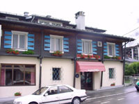
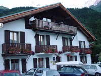
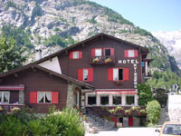
Lodge: Hôtel Au Bon Coin Tel: 04-5053-1567 Open: all year Room: FRF 234-384/double B: add'l FRF 35/pax V/MC |
Days 11 & 12: Chamonix (France) to Les Houches (France)
The weather forecast predicted another day of clouds and drizzle followed by clear skies and summer conditions. We were ready to move from Chamonix and positioned ourselves at the Hotel Slalom which sat at the TMB trailhead from Les Houches to Les Contamines. Because of rain and low clouds, we rode the train from Chamonix to Les Houches instead of hiking the route recommended by Harper's book.
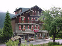
Hotel Slalom was the best overnight on the TMB trip to date. Its location is a 30 minute walk from the train station, a few paces beyond the Bellevue gondola station in the eastern-most part of Les Houches. Hotel Slalom was opened by a Swedish couple last year. Stay for dinner. It's truly gourmet. If you aren't fortunate enough to get a room at Hotel Slalom, still stop by for dinner.
Hotel Slalom has a new chef who can't cook. We no longer recommend dinner here.|
|
Lodge: Hotel Slalom Tel: 04-5054-4060 http://www.hotelslalom.com/fstart.html info@hotelslalom.com Open: all year Room: FRF 270/double B: add'l FRF 35/pax FRF 329/double FRF 312/pax room w/ D & B V/MC |
Day 13: Les Houches (France) to Les Contamines (France)
Hooray! After 8 consecutive days of rain, the clouds blew elsewhere. The sun shone, the mountains were visible, and Wes' cold was nearly gone. It pays to be patient.
We thought about earlier times when our vacation was limited. What would we have done had the weather turned sour during our precious 2 week vacation from work?
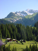
Accustomed to sleeping in late on rainy days, we had trouble getting up and started the hike late. Making use of the Bellevue gondola, we traveled the distance equivalent to 2.5 hours of hiking. From the top of Bellevue, we were in good shape. Another 5 hours of hiking up a saddle called Col de Tricot, down 2000 ft to the town of Miage, up a ridge to an outpost called Truk, and down down down to the town of Les Contamines completed our day. Les Contamines has a large selection of accommodation. We picked the first we found and were lucky. La Clef Des Champs is the cheapest hotel in Les Contamines. The owner is a hiker himself and knows the TMB well enough to give good advice.
|
|
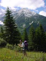
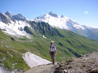
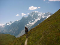
Wes examines the map and decides we're on course to Glacier de Bionnassay. After many consecutive days of clouds and rain, we were elated to continue our trek with views of mountain peaks all around. |
|
|
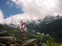
The view of the mountains as we descend from Col de Tricot into the town of Miage. |
|
|
Lodge: La Clef Des Champs Tel: 04-5047-0609 Open: most of the year; call ahead Room: FRF 200-230/double B: add'l FRF 33/pax V/MC |
Day 14: Les Contamines (France) to Bonhomme (France)
Feeling good about the previous days hike, we decided to start early and cover a large distance to a refuge called Motettes located 22km away over mountainous terrain. Fatigue from the vertical ascent was greater than expected, and our bodies forced us to stop 8km short of our target. The scenery was the best so far along the TMB, so overall, we felt the day was a success.
The route from Contamines to Col-de-la-Croix-du-Bonhomme was a continuous ascent from an elevation of 1167 M to 2479 M. As we climbed, the trail turned from warm green valleys to chilly wind swept red rock to snow. Each stage was beautiful in its own right. Our overnight was at a refuge far in the mountains just over and below the Col at 2433 M / 7982 ft. For the first time that night, the sleeping bags we borrowed from friends in Lucerne paid off.
|
|
Two hours from the town of Les Contamines, the TMB trail passed through picturesque valleys spotted with farms. |
|
|
Six hours from Les Contamines, Wes and Masami reach the Col Bonhomme at 2329 M / 7641 ft. The wind was cold against our sweat soaked clothes. |
|
|
Masami continues from Col Bonhomme along a craggy, partially snow covered path towards Col de la Croix du Bonhomme. The scenery keeps getting better and better. |
|
|
Lodge: Refuge De La Croix Du Bonhomme Refuge Tel: 04-7907-0528 Reservations: 02-9988-4915 Open: June 15 - Sept 22 Room: FRF 200/pax w/ D & B L: add'l FRF 42 FRF 82/pax room FRF 85 D, FRF 35 B, FRF 45 L FRF 202/pax room w/ D & B |
Day 15: Bonhomme (France) to Courmayeur (Italy)
Based on distance, the most logical stop after the refuge at Bonhomme is a refuge called Elizabetta, just one hour beyond the French-Italian border. Elizabetta has had its share of bad luck. Several months ago, much of the structure was damaged by an avalanche. Temporary tents were added during refuge repair, but the rains earlier in the week (when we were in Chamonix and Annecy) wrecked the tents. We were told the tents were replaced, but because of limited space, reservations were required. Wes decided against trying to sleep in tents crammed with hikers and thought we could reach Courmayeur with the aid of a bus which stopped some distance beyond Elizabetta.
The morning started wonderfully. We had a clear blue sky and the crunch of ice and snow underfoot; winter hiking in the middle of July! From the refuge, we made an immediate ascent to the highest point of the day, Col des Fours at 2665M / 8743 ft. At this point, we decided we must be at the prettiest part of the TMB. From the Col, we saw the trail descend a snow covered plane with protruding red rock until it leveled out into mossy dampness from the melting snow, then further down into light green grassland as far as the eye could see. On our left and right, huge chunks of granite rose to snowy crests. We were like little kids with arms spread out as we slid down the snow, ran across the dark green moss, and entered the valley far below. 2.5 hours later, we had descended 915 M / 3000 ft to a farmhouse that marked the start of our next ascent up the opposite mountain ridge that separates France and Italy. After 30 minutes of gradual climbing, we reached the refuge at Motettes, our target from the previous day. Motettes serves substantial portions for lunch, and is a good place to stop for food any time of the day.
Motettes to the Italian border was another grueling 2 hour climb to Col de la Seigne at 2516 M / 8255 ft. We pushed ourselves too hard and too fast, and realized too late that we walked without break and drank far too little water. We looked forward to crossing into Italy with a feeling of romance. Masami focused on her desire to eat Italian food in Italy, an urge that consumed her for the past few days.
The saying says that in hell everything is organized by the Italians. Other than the pylon that officially marks the boarder, the lack of trail maintenance was evidence enough that we had reached Italy. The Swiss mark the TMB with white-red-white stripes at regular intervals; the French with red-white stripes. And the Italians? A green splash of paint here, an orange splash there, and how about a yellow circle there? The marking is so inconsistent and irregular that the thousands of lost hikers forge criss-crossing paths this way, that way, and every way causing extensive erosion. At times, the Italians mark the trail every 3 paces and other times we hiked for hours without any indication that we were still on the right track. Carry a good topological map in Italy.
From the border, the nearest bus was a bit further than we had hoped. 3 hours later, exhausted, dehydrated, and over heated, we found the bus for Courmayeur. Be sure to have some Italian Lira in your pocket before crossing over from France.
In Courmayeur, the Tourist Information Office is conveniently located at the terminal station for all buses coming to Courmayeur. They speak English (thank you!) and will gladly find you a hotel. We tried 2 hotels. Our first night in Courmayeur, we stayed at Lo Scoiattolo. It was selected based on proximity; we were much too tired to walk anywhere more than a few minutes away. Lo Scoiattolo gets a "thumbs down". If you're in Courmayeur for business, I'm sure it's fine. The rooms even have TV with CNN to catch up on worldly happenings in English. Unfortunately, it doesn't feel like Italy - it's a sterile cultureless business hotel.
The next hotel, Svizzero (info and photo below), we liked. An energetic and extremely helpful and friendly family runs the place. Grandma at reception gets distracted from work to yell at her rowdy granddaughters. Mama and Grandma not only find information for us, they telephone and make the reservations too. We communicate in broken English and broken French with bits of Italian thrown in here and there and lots of hand movement. Very fun.
|
|
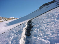
The snow on the trail from Refuge De La Croix Du Bonhomme to Col des Fours is still crunchy at 09:00. |
|
|
Wes nearly half way down the Plan des Fours. As we descend 3000 feet, the snow disappears and the green ground gets lighter in color. |
|
|
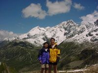
In record time we reach Italy. Masami stands at the Col de la Seigne with one foot in France and one in Italy. |
|
|
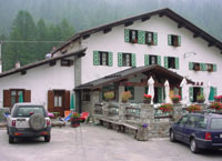
Lodge: Hotel Svizzero Tel: 0165-84-20-35 Open: all year Room: ITL 110,000/double w/ B ITL 140,000/double w/ D & B for 2 V/MC |
Day 16: Courmayeur (Italy), heat stroke recovery
Day 15 was too aggressive. We moved too far too fast without breaks to drink water. Our first night in Courmayeur was far from restful. Wes was vomiting and had a migraine making sleep impossible. Masami had a headache, grumbling stomach, and an incoherent Wes who kept her awake with his voiced agony.
We somehow managed to switch hotels from Lo Scoiattolo to Hotel Svizzero, drank lots of water, and slept most of the day. We found one of our physical limits and must now remember not to try to speed hike for more than 7 hours in the sun without drinking lots of water.
In the afternoon, we went for a much needed massage at Centro Estetico Body Works. Reservations are required. Tel: 0165-84-20-99. Its a 15 minute walk from the information center in Courmayeur.
Day 17: Courmayeur (Italy) to La Vachey (Italy)
Day 17 was almost another recovery day. We looked outside and saw another clear sky. Our heads hurt mildly and Wes wasn't sure if breakfast would stay down, but we thought we could manage a leisurely hike that Harper's book recommended 5 hours for. We'll hike slowly and give ourselves 7-8 hours for this 5 hour course, we decided. And we'll drink lots of water.
This route from Courmayeur to La Vachey turned out to be the best of the best hikes on the TMB. Unlike the previous strenuous hikes from Les Contamines and Bonhomme, the hike was fairly moderate. The highlight of the walk was a 2 hour stroll along the top of Mont de la Saxe, a grassy 2200 M / 7200 ft foothill that parallels the Alps peaks. Directly in front of us towered Mont Blanc and its surrounding peaks and glaciers. Far to the left, we could see all the way to Col de la Seigne, the French-Italian border we crossed 2 days before. Far to the right was a mountain ridge that separates Italy and Switzerland. The view was too spectacular, too broad, to capture in a photograph. Wes made a few 180° mpeg videos to try to capture the scenery, but really, this place needs to be visited to be appreciated.
Hotel selection in La Vachey is easy. There's one choice.
|
|
Masami walking along the Mont de la Saxe with Mont Blanc in the background. The Italians forgot to mark vast stretches of this trail as TMB, but with a map, it's easy enough to follow. |
|
|
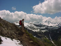
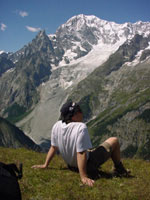
Wes takes a break to admire the scenery, drink more water, and rest his overexerted body. Ahhh... if every day could be like this. |
|
|
Lodge: Hotel La Vachey Tel: 0165-86-97-23 Open: June 18 - Sept 26 Room: ITL 68,000/pax w/ D & B ITL 70,000/pax w/ D & B V/MC |
Day 18: La Vachey (Italy) to Chamonix (France)
Feeling much better, we left La Vachey early for a moderate hike to La Fouly (Switzerland) from which we intended to find bus and train to Chamonix.
The highlight of this section is a view of Mont Dolent, the point where France, Switzerland, and Italy meet. Otherwise, this hike was less interesting than the previous hikes between Les Contamines and La Vachey.
From La Vachey, we cheated the first bit by taking a bus uphill for about 15 minutes. That short ride cut a full hiking hour from our route. However, with over 4 hours of walking ahead of us, we started early.
2 hours of walking from the bus stop took us to Col du Grand Ferret, the Italian-Swiss border, from which Mont Dolent was clearly visible. After another 2.5 hour descent, we were in the Swiss town of La Fouly where we found a bus to Orsières. From there, trains travel north to Martigny, the train hub for the St. Bernard Express which runs to Chamonix.
We completed the hike to La Fouly early enough to make each of the bus and train connections to Chamonix. It wasn't until the St. Bernard Express departed Martigny that we thought Chamonix may be beyond reach this day. 15 minutes into the train ride, our St. Bernard decided to stall in a tunnel on a steep incline. The conductor, red faced and puffing, ran back and forth from the front to the rear to push buttons, reset the system, turn the lights on and off, and call for help.
Stuck on an incline in the dark, we thought of the worst: what if the breaks also fail and we roll backwards down the hill uncontrollably? Wes thought of an escape route, and Masami remembered a novel where someone died in a similar situation. We were fortunate. Technical support arrived and sent us on our way an hour later.
In Chamonix, we returned to the Hôtel Au Bon Coin where we stayed 8 days ago.
|
|
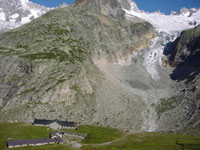
We look down upon Refuge Pré De Bar sitting in front of Pré De Bar Glacier as we ascend toward Col du Grand Ferret which marks the Italian-Swiss border. |
|
|
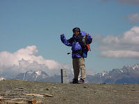
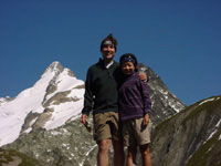
Wes and Masami at Col du Grand Ferret with the snow covered Mont Dolent in the background. |
|
|
Lodge: Hôtel Au Bon Coin Tel: 04-5053-1567 Open: all year Room: FRF 234-384/double B: add'l FRF 35/pax V/MC |
Day 19: Chamonix (France), the finish
Because we missed the mountain scenery in Chamonix earlier on the TMB due to rain, we decided to return for a day to hike sections recommended by Harper's book. Low clouds covered the Mont Blanc peak, but still we decided to hike a short 8km loop between La Flégère, Index, and Lac Blanc. Our objective was twofold: we wanted to see the often photographed Lac Blanc, and we wanted one last chance to find Alps mountain goats said to be walking the hills someplace beyond our view. Luckily, both goals were accomplished. During the return from Lac Blanc to La Flégère, we were drenched by another rainfall. Do the rains follow us to Chamonix or do we bring them?
|
|
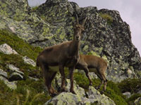
A marvelous mountain goat sighting between Index and Lac Blanc. For 2 weeks through France, Italy, and Switzerland, we looked for goats without success. Masami was the first to spot these. |
|
|
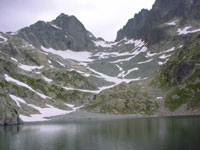
The serene crystal clear Lac Blanc at 2352 M / 7717 ft. Easy access by cable car to La Flégère followed by a 4km gradual ascent makes this a popular day hike from the Chamonix area. |
The end of a long Tour of Mont Blanc. We'd do it again. Definitely.
Copyright © 2000-2002 Wes and Masami Heiser. All rights reserved.