![]()
| Switzerland/Austria | Rhätikon Höhenweg | 2000.08.16 - 08.17 |
The Rhätikon Höhenweg Trek
Good friends Hernan and Tim flew all the way to Switzerland to hike with us for a few days. Hernan is a regular hiking buddy from California who's featured in an earlier page about Mt. Shasta. Tim did a moderate amount of hiking with us in California before he moved to London. Wanting to make their trip worthwhile, we selected the most interesting sounding hike from the "Walking in Switzerland" Lonely Planet guide.
The Rhätikon Höhenweg starts in Switzerland from a small town called St. Antönien (1420 M / 4659 ft). The trail makes a sudden ascent to 2100 M / 6890 ft before leveling off at the Carschina Plateau. There is little elevation change for the next 10 km / 6.25 miles until a scramble up a steep cliff to Schweizertor, the border crossing into Austria. An additional 2½ hours of walking in Austria takes the weary hiker to a large mountain lodge on the Lünersee (Lüner Lake) called Douglashütte (1979 M / 6493 ft). From Douglashütte, the trail climbs directly to Schesaplana (2964 M / 9724 ft), the highest point in the mountain chain that separates Switzerland from Austria. Then it descends rapidly into Switzerland for a 16 km / 10 mile walk into Liechtenstein. The guide recommends 3-4 days for this hike, but we thought 2 days was possible. We were wrong.
Hernan and Tim's schedule was locked by flight itineraries. They had 2 full days from Küblis, a small town 30 minutes by bus downhill from St Antönien, to Zürich. Extension, according to their work priorities (they're both employed), was not possible. We began our first day bound for Douglashütte in Austria. As we approached the lodge 9½ hours later, our strength and muscles pleaded with us to reconsider the longer and more strenuous second day that, if attempted, had to reach the last bus in Malbun, Liechtenstein by 19:02. Failure to catch that bus meant that our guests would miss their flights to London. Over a voluminous dinner and a topological map, we explored our second day options. We decided to reach Schesaplana, return to Douglashütte, and use a gondola and bus to take us to the closest train station in Austria. From there, we guessed that reaching Zürich would be easy. With this plan in mind, day 2 went smoothly. Other than some sore knees, we had no injuries and safely reached Zürich in time for a late dinner.
Although Masami and Wes chose a hike that happened to be a bit too aggressive, we hope that Hernan and Tim will entrust us with future schedule planning and join us on hikes in many more countries.
|
|
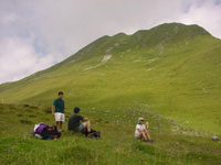
Masami, Tim, Hernan, and Wes take a short break at the Carschina Plateau. The grass covered plains were pretty but hazy skies limited views of the surrounding mountainous country. |
|
|
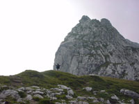
Hernan reaches Schweizertor, our border crossing from Switzerland to Austria. Recalling the "Sound of Music", he raises his arms and sings the opening song for all the cows to hear. |
|
|
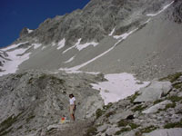
On day 2, Masami begins the steep climb to Schesaplana. Loose rock and snow on steep trails made parts of this climb both scary and dangerous. |
|
|
From the top of Schesaplana, we could look down on Brandner Glacier, the only glacier sitting directly on the Swiss-Austrian border. |
|
|
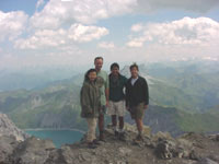
We stand on Schesaplana with Lünersee 1000 M / 3280 ft below in the background. It was a perfect day for a good hike in the Alps. |
Copyright © 2000-2002 Wes and Masami Heiser. All rights reserved.