![]()
| Switzerland | Interlaken | 2000.07.31 - 08.03 |
Interlaken and its Surroundings
The city of Interlaken is named for its location between 2 lakes, Lake Thun and Lake Brienz. Several train and bus lines pass through Interlaken making the city an ideal base from which to day hike. Interlaken has 2 train stations, Interlaken West and Interlaken Ost. Get off the train at Interlaken West where the tourist information office, restaurants, hotels, and shopping are near.
On our way to Interlaken, we learned from another train passenger that August 1st is Swiss National Day. We were rewarded with a fireworks show in the center of Interlaken.
Do not eat at the Japanese restaurant in Interlaken. To put it bluntly, the food is crap.
|
|
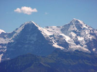
The famous Eiger Mountain (dark pyramidal shape) is clearly visible from the foothills that surround Interlaken. The rock face is considered the most dangerous vertical climb in the world because of falling rock and ice. |
Stockhorn
Like almost all Swiss Alps foothills, Stockhorn peak is accessible by gondola. The trail marker at the base of the gondola station clocks the hike to the top at 4 hours 30 minutes. But because we dislike seeing swarms of people who are clearly out of shape at our destination after we endure a long and exhausting walk, we decided to join them on the gondola.
From the top of Stockhorn, the views were fabulous. We could see Mt. Blanc in France, Wildstrubel (from which we had just descended that morning), the Eiger, and Jungfrau. Being a clear day, the crowds were intense. 100s of people huffed and puffed their way up the 50 steps from the upper gondola station to the very top of Stockhorn. As we tried to wait patiently for others to catch their breath before taking their next 10 steps, we reminded ourselves never to let our muscles atrophy to such a state of disuse.
|
|
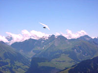
From the top gondola station, hand gliders launch off a wooden platform and sail into the sky. Watching the gliders walk off the ledge before catching oncoming wind is scary enough to convince us that hand gliding is best left to others. |
The Justistal
The Justistal is known for its perfect horseshoe shaped pass between two parallel 2000 meter ranges. A 10 mile day hike, made easy with the assistance of a gondola that takes tourists to a peak called Niederhorn, is possible, circling from the ridge to the Justistal valley and finally back to the lower gondola station. We would recommend a 3 hour hike from the upper gondola station to a lookout called Gemmenalphorn and back, and not the full 10 mile loop we walked. The walk through the Justistal valley follows a paved road and is uninteresting.
|
|
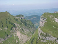
The perfect horseshoe shape of the Justistal is the attraction that draws hikers to this valley. The peaks on either side of the valley rise evenly to 2000 meters. |
|
|
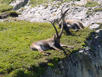
Our first sighting of wild ibex in Switzerland was along the Justistal trail. We didn't realize how large they were until we got close. They're about 5 feet tall standing on 4 legs and must weigh in excess of 300 pounds. |
Copyright © 2000-2002 Wes and Masami Heiser. All rights reserved.