![]()
| Kyrgyzstan | Karakol | 2002.08.10 - 08.26 |
Terskey Alatau Treks
The town of Karakol at the foot of the Terskey Alatau Mountain Range is an excellent trekking base. Walks lasting 1 to 5 days ascend the Ak-Suu, Arashan, Karakol, Jeti-Öghüz, and Kyzyl-Suu River Valleys. Some trails are steep while others are flat. Some have basic huts while others require tents. All trails have coniferous forests, wild flowers, grasslands, steep craggy peaks, glaciers, and forceful glacial rivers. A trekking permit (US$8 for each 3-day block or US$30 for 30 days) is required to hike through the valleys. In addition, a US$5 national park admission is required to hike up or cross through Karakol Valley. Many trekkers walk for 3~5 days up one valley and down another. Camping is permitted anywhere in the Terskey Alatau Range, though flat spots near a water source are few and far between.
CAMPING GEAR RENTAL
Camping gear like tent, sleeping mat, and stove can be rented for a few dollars per day
from Novinomad, one of the tourist information offices near the Internet Cafe in the center of Karakol.
We paid a daily rate of US$3 for a dome tent, US$1.50 for a stove, and US$0.50 for a sleeping mat.
FOOD AND WATER
Lightweight dry camping food is unavailable in Kyrgyzstan. Prepared trekkers bring these food packets
from their home countries. Local food purchased at the market in Karakol is limited to dried noodles,
vegetables, fruit, biscuits, bread, processed cheese, and chocolate. Carrying a multiple-day supply
of these groceries adds a considerable number of kilos to the backpack weight. Also, if crossing
from one valley to another, the probability of going astray is high. We recommend carrying an extra
day of food in the event that backtracking is necessary.
2 houses in Altyn Arashan Valley sell a meal for between US$3~5. Otherwise, the only food available in the Terskey Alatau Mountain Range is the food in your pack.
Most rivers in the Terskey Alatau Range are dense with glacier sediment. A water filter that can be cleaned in the field (like MSR) is preferable to water purification tablets. Between valleys, many rivers run underground, making the water source inaccessible. Carrying a 2-liter water supply per person is recommended.
TOPOLOGICAL TREKKING MAPS
Topological maps of Kyrgyzstan have inaccuracies. The most detailed map of the Terskey Alatau Range is
the TePCKeŇ ALA-TOO available for Ks 50 at the Tourist Information Office in Bishkek. Maps cannot
be purchased in Karakol. After choosing a route, ask other trekkers and locals to verify every detail
on the map before setting out. Some of the inaccuracies are blatant: documented trails on the wrong
side of a river, undocumented forks from the main trail that lead for hours to dead ends, missing
bridges, and some missing mountains. The less detailed 1:100,000 scale topological map of the area
is worse. The trails over passes aren't documented whatsoever, marked elevations are inaccurate by
several 100 meters, and huge mountains are missing.
GETTING TO KARAKOL
Buses from Bishkek depart for Karakol hourly. Bus travel time is about 8 hours and costs Ks 140 (US$3.09).
Alternatively, minibuses depart Bishkek for Karakol when they fill. Minibus travel time is
about 6.5 hours and costs Ks 200 (US$4.42).
ALTYN ARASHAN VALLEY
The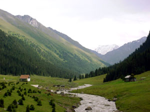 most popular of the 5 river valleys is Altyn Arashan. 14km upstream from the town of Ak Suu
(10km to the east of Karakol) is a hamlet of 4 cabins. This is Altyn Arashan. Overnight lodging is available at all 4
cabins, normally for Ks 100 (US$2.21) per person per night. 2 of the cabins (the one furthest up the valley
and the one across the river) have their own private hot spring hut. The remaining 2 cabins rely
on the public hot springs baths that charge Ks 50 (US$1.10) per person per use. We stayed in the cabin
across the river. Use of their private hot springs hut was Ks 20 (US$0.44) per person per use in addition to
their Ks 100 per person per night cabin fee. We brought our own food from Karakol to cook
on the cabin's outdoor wood-burning stove. The first cabin (which is more like an old dilapidated trailer)
charges US$5 per meal. The second house charges US$3 for dinner and US$2 for breakfast. Other than
at these 2 houses, there is no food available for purchase in Arashan Valley.
The family of the cabin we stayed at provided a kettle, cooking pot, utensils, and firewood
for our meals. Water comes from a mountain source. We filtered it with our MSR water purifier
before drinking. Nights are cold even in mid August. A sleeping bag and warm clothing are
necessary. Also, beware of the food thief. We padlocked our door when out. Yet each day we returned
to find food missing. We discovered that a child could crawl under the cabin and enter our room through
a loose floorboard. It was curious to discover one wedge of cheese, some cookies, and a slab of
chocolate bar missing when our gear was untouched. If you find a loose floorboard, maybe
it's best to pile some heavy rocks atop it before going out.
most popular of the 5 river valleys is Altyn Arashan. 14km upstream from the town of Ak Suu
(10km to the east of Karakol) is a hamlet of 4 cabins. This is Altyn Arashan. Overnight lodging is available at all 4
cabins, normally for Ks 100 (US$2.21) per person per night. 2 of the cabins (the one furthest up the valley
and the one across the river) have their own private hot spring hut. The remaining 2 cabins rely
on the public hot springs baths that charge Ks 50 (US$1.10) per person per use. We stayed in the cabin
across the river. Use of their private hot springs hut was Ks 20 (US$0.44) per person per use in addition to
their Ks 100 per person per night cabin fee. We brought our own food from Karakol to cook
on the cabin's outdoor wood-burning stove. The first cabin (which is more like an old dilapidated trailer)
charges US$5 per meal. The second house charges US$3 for dinner and US$2 for breakfast. Other than
at these 2 houses, there is no food available for purchase in Arashan Valley.
The family of the cabin we stayed at provided a kettle, cooking pot, utensils, and firewood
for our meals. Water comes from a mountain source. We filtered it with our MSR water purifier
before drinking. Nights are cold even in mid August. A sleeping bag and warm clothing are
necessary. Also, beware of the food thief. We padlocked our door when out. Yet each day we returned
to find food missing. We discovered that a child could crawl under the cabin and enter our room through
a loose floorboard. It was curious to discover one wedge of cheese, some cookies, and a slab of
chocolate bar missing when our gear was untouched. If you find a loose floorboard, maybe
it's best to pile some heavy rocks atop it before going out.
From Altyn Arashan, countless walks are possible. The more strenuous trail climbs 1300 meters to the top of a pass that overlooks Ala-Kul glacier lake. Another difficult trail crosses a raging ice-cold waist-deep river several times before reaching the base of a glacier about 2 days distant. Because of poor weather, we chose some easier walks up the nearby hills where the flowers bloomed and the horses grazed.
After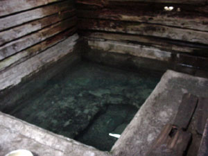 an Arashan Valley walk, the hot spring awaits. The springs bubble up into a concrete
pool that's enclosed in a small private cabin. Bathing is Japanese style - disrobe, rinse your
body with the mineral water outside the tub, then get in for a long warm soak. No swimwear needed.
Soap and shampoo are prohibited. We relaxed in the warmth while gazing out the window at the
mountaintops. These hot springs make up for the rustic lodging and cooking facilities.
an Arashan Valley walk, the hot spring awaits. The springs bubble up into a concrete
pool that's enclosed in a small private cabin. Bathing is Japanese style - disrobe, rinse your
body with the mineral water outside the tub, then get in for a long warm soak. No swimwear needed.
Soap and shampoo are prohibited. We relaxed in the warmth while gazing out the window at the
mountaintops. These hot springs make up for the rustic lodging and cooking facilities.
GETTING TO ALTYN ARASHAN
Option 1: Three blocks northeast of Yak Tours Hostel is the bus to Ak Suu (AK Cyy). Departures are approximately hourly
from early morning. The fare is Ks 5. From the terminal stop in Ak Suu, follow the paved road toward the
mountains. 40 minutes by foot later, the paved road forks. The right fork that is dirt road
continues for 14km to Altyn Arashan.
Option 2: A minibus runs between Karakol and a small town south of Ak Suu, also called Ak Suu.
In Karakol, flag down this minibus 2 blocks northeast of Yak Tours Hostel. Bus fare to the
Ak Suu - Altyn Arashan junction is Ks 10.
Locals driving to Altyn Arashan will offer tourists a ride
to supplement their income by a buck or two. A jeep waited for us and asked Ks 100 per person for the
14 km ride. We accepted. The road is rough and requires 4WD in several places.
Alternatively, if you want comfort and speed at 14 times the price, Yak Tours Hostel sells a US$25 per person package that includes transport to Altyn Arashan, one night lodging in a not-so-clean cabin, dinner, and breakfast. Yak Tours will insist on the additional purchase of the US$8 per person permit fee.
JETI-ÖGHÜZ VALLEY
25km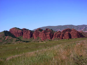 to the west of Karakol is the Jeti-Öghüz Valley. Its unique feature is red sandstone
rock at the entrance of the valley. Also at the entrance is a sanatorium for medical rehabilitation
and a simple town of wooden houses and large concrete soviet-style buildings. One day, Novinomad
and UNESCO sponsored a food fest up the Jeti-Öghüz Valley as part of an ill-advertised
tourism promotion activity. All tourists in Karakol were invited for a free lunch prepared by 6
families, each representing a different ethnicity of Kyrgyzstan. Our only responsibility was to pick
our favorite type of food among the prepared Uyghur, Kyrgyz, Tater, Uzbek, Russian, and Dungan (Chinese Muslim) dishes.
Would any tourist decline this invitation? During our meal, talented Kyrgyz musicians performed local
folk songs. We were also shown wool carpet-making techniques. Never were any of the tourists asked to
purchase something. One tourist asked if he could make a contribution to the sponsoring
organizations. In reply the organizer agreed, "Yes, you can vote for your favorite food!"
The event was an enjoyable picnic. Had the organizers advertised better, there
would have been more than 25 participants and the locals in the town of the Jeti-Öghüz
Sanatorium would have known about it.
to the west of Karakol is the Jeti-Öghüz Valley. Its unique feature is red sandstone
rock at the entrance of the valley. Also at the entrance is a sanatorium for medical rehabilitation
and a simple town of wooden houses and large concrete soviet-style buildings. One day, Novinomad
and UNESCO sponsored a food fest up the Jeti-Öghüz Valley as part of an ill-advertised
tourism promotion activity. All tourists in Karakol were invited for a free lunch prepared by 6
families, each representing a different ethnicity of Kyrgyzstan. Our only responsibility was to pick
our favorite type of food among the prepared Uyghur, Kyrgyz, Tater, Uzbek, Russian, and Dungan (Chinese Muslim) dishes.
Would any tourist decline this invitation? During our meal, talented Kyrgyz musicians performed local
folk songs. We were also shown wool carpet-making techniques. Never were any of the tourists asked to
purchase something. One tourist asked if he could make a contribution to the sponsoring
organizations. In reply the organizer agreed, "Yes, you can vote for your favorite food!"
The event was an enjoyable picnic. Had the organizers advertised better, there
would have been more than 25 participants and the locals in the town of the Jeti-Öghüz
Sanatorium would have known about it.
GETTING TO JETI-ÖGHÜZ
Buses run from Karakol to Jeti-Öghüz twice per day. Alternatively, hire a taxi.
From Karakol to Jeti-Öghüz Sanatorium round-trip with 4-hour wait-time cost us
Ks 500 (US$11). The dirt road up the valley is level enough for any car.
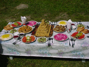 |
Each of the 6 families "competing" in the Jeti-Öghüz food fest prepared ethnic specialty dished with care. This table featured Tater food. |
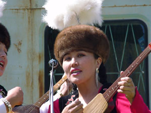 |
Kyrgyz musicians at the Jeti-Öghüz food fest were extraordinarily talented. Their voices and string instruments harmonized in beautiful folk tunes. |
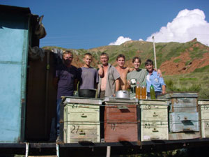 |
Buying honey from a beekeeper in Jeti-Öghüz Valley isn't a simple shopping matter. Like most of our experiences in Kyrgyzstan, we were invited to drink some home brewed honey wine, handed watermelon slices, and asked all sorts of questions about our origins. Normally one person in the Kyrgyz or Russian group speaks some English and acts as a translator for everyone in the vicinity. While waiting for the drunken beekeeper to fill a PET bottle with 1kg of honey, the entire family gathered for a photo with us, their foreign guests - now friends. |
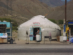 |
Kyrgyz yurts are a common site throughout Kyrgyzstan. These yurts sell beverages and snacks to passersby between Bishkek and Karakol. |
KARAKOL VALLEY TO ALTYN ARASHAN VALLEY
Directly south of the town of Karakol is Karakol Valley. A tollgate at the entrance of the valley
collects US$5 per foreigner for national park admission. The paved road continues for another 5km.
From there, a dirt road leads up the valley. A taxi can travel 10km beyond the entrance gate.
4WDs can travel 20km in. A taxi from the center of Karakol charged us Ks 180 to the first
river crossing 10km up the valley.
From the taxi drop-off, we walked another 10km to a log-bridge river crossing that put us on a meandering trail through a forest toward Ala-Kul Lake and the 3720-meter high pass that crosses to Altyn Arashan Valley. Fortunately, 3 young Russian hikers pointed us across this log crossing. According to our topological map, the logs should have been after the 3rd vehicle bridge in the valley. Actually, the only vehicle bridge we crossed was 10km downriver where the taxi dropped us off.
After crossing the forest, the trail climbed more steeply. The map showed a river that we should have been walking parallel to. There was none. Then at 2835 meters, we reached a small azure lake at the foot of a gushing river. Having walked for 5 hours uphill, we stopped here for the night.
Our second day was frustrating. Our aim was to climb to Ata-Kul Lake (at 3535 meters according to the map). 1km and 100 meters higher than camp, the trail forked. Cairns clearly marked a trail that climbed steeply up a glacier. The trail along the river was unmarked. We followed the cairns. This was a mistake. The cairns led us to the top of the glacier. At 3600 meters, 6 hours of climbing later, we found ourselves in a bowl of steep jagged peaks. No lake was below. We had no choice but to descend the unstable 800 vertical meters of sharp rock to camp. We lost a full day of time, food, and energy. Furthermore, because of poor footing, we both had bleeding wounds on hands and arms from stumbling down loose rock. We later learned that other trekkers making the same directional mistake often become discouraged and return down Karakol Valley without crossing the pass to Altyn Arashan Valley. On this day, after 9 hours of hard walking resulting in zero progress, we felt discouraged in the same way but decided to sleep off our frustration and decide our course the next morning.
We awoke on day 3 with a renewed determination to reach Altyn Arashan Valley. Climbing the trail parallel to the river, we reached Ata-Kul Lake before noon. The actual altitude according to Wes' altimeter was 3355 meters, not 3535. As other trekkers described, Ala-Kul Lake was a gorgeous azure glacier lake surrounded by spiked peaks. It's a perfect place to camp or picnic.
From Ala-Kul Lake, we knew from a mistake suffered by an Israeli couple we met at Yak Tours Hostel that we needed to follow the track that says level 100 meters above the lake's north bank for 1.5 km. Unfortunately, they chose to follow cairns that climbed for hours to another dead end, ran out of food and energy, and were forced to retreat back down Karakol Valley without reaching the pass.
From the middle of Ala-Kul Lake, we could see the pass to Altyn Arashan high above. Reaching the 3720-meter high pass over loose rock and scree took hours of exhausting effort. But when we reached the top, the view of glaciers flowing down from 4000 and 5000-meter high mountains was reward enough. A fierce icy wind blew over the pass, preventing a long stay
Luckily, a guided group of Europeans also reached the pass from Altyn Arashan at the same time. We followed them back into Arashan Valley without concern of getting lost a second time. Our relief was premature. With a horse carrying their day-hike bags, they moved down the mountain quickly. Within 3 hours, they were out of sight. And again we went off course. Cow tracks ran left and right. Distinguishing which track was the human track to Altyn Arashan and which were the cow tracks that would invariably lead through dense brush was nearly impossible. Again the map was no help. We evidently followed a cow track of a cow that liked to tunnel through pine forest, dense shrubs, and thorns, straddle precipices adjacent freezing glacier rivers, fall down steep grassy banks, climb uprooted tree trunks, and cling to rock faces. The last 400 meters of descent was a hard 5 hours of bushwhacking that we care not to repeat.
Fatigued with sore feet, dirt under our fingernails, minor bleeding, and wobbly knees, we reached Altyn Arashan at the late hour of 20:00, more than 11 hours after departing camp. Fortunately, the guides working for Yak Tours Hostel prepared dinner for us. Otherwise, we would have eaten our last onion raw and fallen flat on our faces from exhaustion. After dinner, we soaked our sore bodies in a mineral hot spring. Every hike should end with a hot spring. It's pure delight.
The next morning, thanks to the hot spring, we could walk. A quick-paced 3-hour walk to Ak Suu and a short minibus ride delivered us to Karakol to complete our 3-day circuit. Had we found the proper trails, this hike would have been fairly easy in 3 days. Unfortunately, there's only one way to learn the route unguided - the hard way.
 |
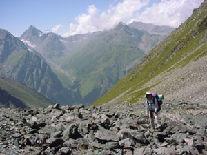
We reach camp after one day of hiking. At this point, we're on course and expect the remaining trail to Altyn Arashan to be straightforward. Wrong. |
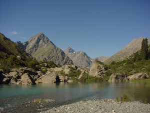 |
The clear mineral lake next to our campsite is an excellent water source and soothing to gaze at. |
 |
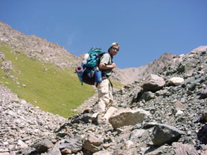 |
| Masami and Wes struggle up steep loose rock to a 3600-meter high dead end. Frustrated, exhausted, and discouraged, but we still manage to return to camp and attempt Ala-Kul Lake the next day. | |
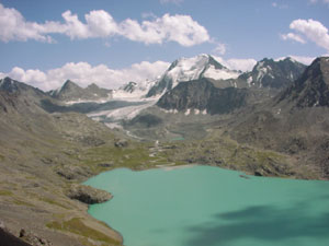 |
Ata-Kul Lake is a gorgeous 1.5km-long azure glacier lake. It's an ideal camping and picnic spot. |
Copyright © 2000-2002 Wes and Masami Heiser. All rights reserved.