![]()
| France/Italy/Switzerland | Tour du Mont Blanc | 2001.07.28 - 08.04 |
Tour du Mont Blanc (TMB), 2001
After hiking the TMB circuit in July 2000, we knew we'd return again. A year later, we found ourselves in France and allocated one week for a second loop. We will briefly repeat some introductory information.
Books on the TMB:
1. "Tour of Mont Blanc" by Andrew Harper, published by
Cicerone Press. Details an 11-day counter clockwise loop per the author's
recommendation. Includes a description of the terrain,
hiking distances and times, recommended stops, accommodation options,
and various alternate hiking, bus, and train routes between stopovers
that may appeal to the more rugged or less energetic. Phone numbers for
accommodation in Switzerland are outdated.
2. "Around Mont Blanc", a Rother Walking
Guide ( http://www.rother.de )
by Hartmut Eberlein published in English. Has color photos, detailed color
topological hiking maps, and trail descriptions. Lacks accommodation
information.
The Chamonix SNCF train station stores luggage for FRF 20 per day per piece. There is no time limit. Hotels generally let you store luggage free of charge if you plan to return for an additional night.
Several hotels and refuges on the TMB only accept cash (their own country's). Be sure to have Swiss Francs, French Francs, and Italian Lira in your wallet before starting. We recommend carrying the equivalent of US$200 per person in each currency. Chamonix, Les Houches, and Les Contamines in France, Courmayeur in Italy, and Champex in Switzerland have cash machines on the Plus and Cirrus networks. On 1 January 2002, French and Italian currencies will be replaced by the Euro. Switzerland will not join the European Union and will retain the Swiss Franc.
Buy the blue 1:25,000 ratio Institut Geographique National (IGN) hiking maps 3531 ET "St-Gervais" and 3630 OT "Chamonix". An alternate (but more difficult to find) is the 1:50,000 ratio "Pays du Mont Blanc, 8. Mont Blanc, Beaufortain, Aravis, Val d'Arly" by Didier Richard.
Useful Tourist Information
Office numbers:
Chamonix Tourist Information 04-5053-0024 (Int'l +33-4-5053-0024)
Les Contamines Tourist Information 04-5047-0161 (Int'l +33-4-5047-0161)
Courmayeur Tourist Information 0165-842060 (Int'l +39-0165-842060)
Key used for lodging:
B = breakfast;
L = lunch;
D = dinner
V = Visa credit card accepted;
MC = Master Card credit card accepted
CHF = Swiss Franc; FRF = French Franc; ITL = Italian Lira
|
July 28, 1st night in Les Houches (France) |
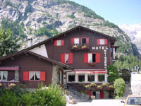
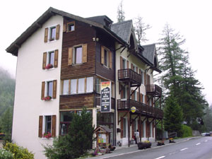
After a long drive from the Loire Valley, we reached Les Houches. We chose Les Houches as our TMB starting point specifically because of the excellent dinner prepared by Hotel Slalom last year. Disappointingly, Hotel Slalom has a new chef. The meal tasted like a microwave defrosting of sub-quality ingredients that stayed in the freezer beyond their expiration date. To make matters worse, Hotel Slalom prices increased 12% over the previous year. We no longer recommend this hotel. Telephone the Chamonix Tourist Information Office for a list of alternates.
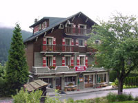 |
Lodge: Hotel Slalom Tel: 04-5054-4060 http://www.hotelslalom.com/fstart.html info@hotelslalom.com Open: all year Room: FRF 329/double FRF 312/pax room w/ D & B V/MC |
|
July 29, Day 1: |
Les Houches (France) to |
Cumulative
ascent: 1497 meters (4911 feet)
Cumulative descent: 1340 meters (4396 feet)
Walking Distance: 18 km (11.25 miles)
We woke up to clear weather and sunny skies. Fantastic, considering that we had 15 rain days out of 23 in July 2000. We walked the same TMB variation route as a year ago, departing Les Houches at 10:00 and reaching Les Contamines at 17:00.
Route description:
787 meter climb from Les Houches to Col de Voza where sunbathing
tourists carried up by train lounge at a visibly expensive hotel.
Deviate from the main TMB route that follows GR5 and hike past
Bionnassay Glacier to Col de Tricot (2120 meters elevation).
Descent Col de Tricot to Chalets de Miage (1550 meters elevation)
where fruit tarts, drinks, and fresh spring water are available.
Climb 190 meters to Chalets du Truc, then continue down a gentle slope to
Les Contamines (1150 meters elevation).
This section of the TMB isn't the prettiest. Those with limited time should bypass it and begin hiking from Notre Dame de la Gorge, staying overnight in Le Fayet, St. Gervais, or Les Contamines the night before. A bus runs between these towns on the following daily schedule (valid June 30 - September 1):
| except
Satur- day |
Satur- day only |
Satur- day only |
|||||
| Le Fayet train station | 08:35 | 11:20 | 12:55 | 13:10 | 14:50 | 15:45 | 19:10 |
| St. Gervais center | 08:45 | 11:30 | 13:05 | 13:20 | 15:00 | 15:55 | 19:20 |
| Les Contamines center | 09:00 | 11:45 | 13:20 | 13:35 | 15:15 | 16:10 | 19:35 |
| Le Lay | 09:10 | 11:55 | 13:30 | 13:45 | 15:25 | 16:20 | 19:45 |
| Notre Dame de la Gorge | 09:15 | 12:00 | 13:35 | 13:50 | 15:30 | 16:25 | - |
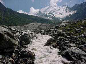 |
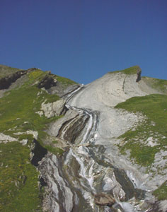
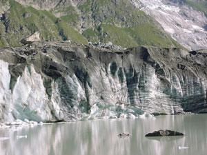
The TMB variation between Les Houches and Les Contamines crosses this gushing river via suspension bridge. In the background is Bionnassay Glacier on the 4304 meter high Dôme du Goûter. |
|
July 30, Day 2: |
Les Contamines (France) to |
Cumulative
ascent: 1269 meters (4163 feet)
Cumulative descent: 29 meters (95 feet)
Walking Distance: 15 km (9.37 miles)
From Les Contamines, we rode the 1st bus coming from St. Gervais to Notre Dame de la Gorge. A 09:15 start is plenty of time to reach the mountain hut at Col de la Croix du Bonhomme by mid afternoon.
Route description:
The trail from Notre Dame de la Gorge climbs steadily past La Balme,
where there's a fresh spring and toilets, to Col du Bonhomme
(2329 meters elevation). Scenery along the trail from Col du Bonhomme to Col de la Croix du Bonhomme
is spectacular with deep valleys and rugged cliffs.
Just over and below Col de la Croix du Bonhomme is the mountain hut.
 |
Wes and Masami pose along the grassy pastures of La Balme. |
 |
Lodge: Refuge De La Croix Du Bonhomme Refuge Tel: 04-7907-0528 Open: June 15 - Sept 22 Room: FRF 202/pax w/ D & B FRF 82/pax room only FRF 85 D, FRF 35 B, FRF 45 L |
|
July 31, Day 3: |
Bonhomme (France) to |
Cumulative
ascent: 1042 meters (3419 feet)
Cumulative descent: 1292 meters (4239 feet)
Walking Distance: 17 km (10.62 miles)
By 08:00, most hikers have eaten breakfast, packed, and started walking, not because of the difficulty that lies ahead, but because of the refreshing mountain air and gorgeous sun rise. Like the year before, we followed a TMB variation up and over Col des Fours and down a steep snow-covered slope through Plan des Fours. Even though the highest peaks around Mont Blanc are hidden from view, this section of the TMB is one of the prettiest. The Andrew Harper book warns against this variant route, claiming that "several people have perished in the gully from Col des Fours", but in reality, this risk is limited to someone who chooses to hike in zero-visibility fog and doesn't have the common sense to avoid walking on a sheet of ice with audible water running beneath. This gully is several 100 meters removed from the trail over a rocky ridge, and one would need to be seriously disoriented to deviate towards it by mistake. We wish Cicerone Press would remove Harper's ominous comment. Many English speakers carrying his book become overly concerned and loop around this fabulous section of the TMB. The French hikers, on the other hand, know about the beauty of Plan des Fours and walk this TMB variation.
Route description:
From Refuge du Col de la Croix du Bonhomme, backtrack 5 minutes to Col
de la Croix du Bonhomme, then turn right to Col des Fours (2665 meters
elevation).
From the top of Col des Fours, several hikers have recommended a short
detour to Tête Nord des Fours (2756 meters elevation) which
overlooks the previous day's hiking trail and has an amazing view
westward. Unfortunately, people told us about Tête Nord des Fours
a day after we crossed Col des Fours. I suppose we'll visit on our
third TMB circuit sometime in the future.
Returning to Col des Fours, the trail descends 876 meters to La Ville
des Glaciers. Along the descent, the terrain gradually changes from
arid rock and scree to lush green pastures with waterfalls.
In La Ville des Glaciers (a small cluster of about 5 stone houses),
buy some homemade Beaufort cheese (FRF 80 per kilo) - they give free
taste tests.
Chalet-Refuge des Mottetes, where an excellent selection is served for
lunch, is a gradual 30 minute ascent from La Ville des Glaciers. Wary
hikers can choose to stay overnight in the Mottetes dorm.
From Mottetes, the trail steadily climbs for 2 hours to the Italian border,
Col de la Seigne (2516 meters elevation).
Rifugio Elizabetta is one hour downhill into Italy.
 |
The Rau des Tufs Waterfall flows down Plan des Fours below the snow line. Marmots can be heard shrieking throughout the green pastures. |
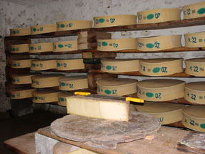 |
The cheese cellar at La Ville des Glaciers. Each pie of Beaufort cheese weighs 40kg. One kg sells for FRF 80, but much smaller pieces can be bought, wrapped, and carried in the backpack along the TMB. |
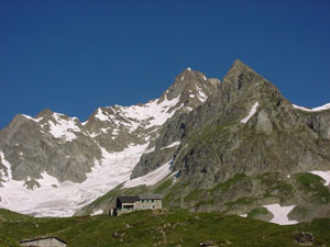 |
Lodge: Rifugio Elisabetta Tel: 0165-84-40-80 Room: ITL 50,000/pax w/ D & B ITL 30,000/pax room only Shower: ITL 8000/pax. |
|
August 1, Day 4: |
Elizabetta (Italy) to |
Cumulative
ascent: 620 meters (2034 feet)
Cumulative descent: 1600 meters (5249 feet)
Walking Distance: 22 km (13.75 miles)
This day begins with a short 1 hour detour to Lac du Miage where the Miage Glacier drops chunks of ice and rock into a small lake. After visiting the lake, the trail leads up a slope on the south side of Val Veni for a level 2 hour walk with views of the Mont Blanc peak to the north.
Route description:
A bridge is reached 45 minutes downhill from Rifugio Elizabetta. Crossing
the bridge and climbing the hill directly in front for 30 minutes leads
to Lac du Miage.
After listening to blocks of ice thunder into the Lac du Miage, backtrack over the bridge and climb the steep ascent up the southern slope of
Val Veni.
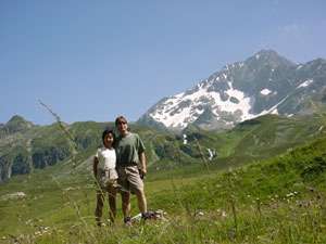
A leisurely 2 hour walk with views of Mont Blanc (Monte Bianco in Italian)
leads to a restaurant on Col Chécroui (1956 meters elevation)
where the pasta lunch is delicious.
From Col Chécroui to Courmayeur, the trail is atrocious. It's similar
to walking through a construction site for 2 hours, but it's the only
walking path/road down to the town.
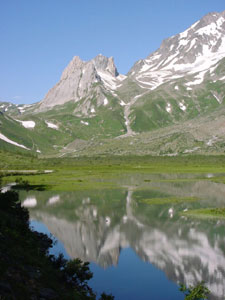 |
45 minutes downhill from Rifugio Elizabetta, the Vallon de la Lée Blanche mountains reflect in the Lac de Combal. |
 |
Loud booming sounds erupt as chunks of ice and rock drop from the Miage Glacier into Lac du Miage. |
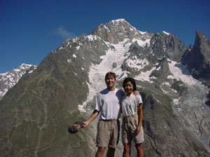 |
On the south slope of Val Veni, Wes and Masami pose in front of the Mont Blanc (Monte Bianco) peak. |
 |
Lodge: Hotel Svizzero Tel: 0165-84-20-35 Open: all year Room: ITL 140,000/double w/ D & B for 2 V/MC |
|
August 2, Day 5: |
Courmayeur (Italy) to |
Cumulative
ascent: 1200 meters (3937 feet)
Cumulative descent: 856 meters (2808 feet)
Walking Distance: 16 km (10 miles)
Our first choice was to hike from Courmayeur to La Vachey but Hotel La Vachey was full. All alternate options were less appealing. We chose to stay in Planpincieux on the main road between Courmayeur and La Vachey to easily catch a bus to Arp Nouvaz, the starting point of the following day's hike.
We wanted to walk along the top of Mont de la Saxe, our favorite section of the TMB the previous year. Even though the Mont de la Saxe trail took us beyond Planpincieux in distance, we decided to go anyway and search for a trail down later.
Route description:
From Courmayeur, the trail climbs 771 meters to Refugio Bertone. The ascent
is shaded by trees and birds are singing.
A steep short climb up another 429 meters from Bertone reaches the top of
Mont de la Saxe.
This being Italy, there are no signs or markers along the trail. All we see
are meandering cow tracks. Our descent from Mont de la Saxe to Planpincieux
involves following cow tracks that eventually lead to a shed in the middle of
nowhere, falling down a hill, and generally walking about lost for 3 hours.
We don't recommend this route.
 |
Lodge: Albergo Planpincieux Tel: 0165-86-97-21 Room: ITL 79,500/pax w/ D & B |
|
August 3, Day 6: |
Planpincieux (Italy) to |
Cumulative
ascent: 768 meters (2520 feet)
Cumulative descent: 837 meters (2746 feet)
Walking Distance: 12.5 km (7.8 miles)
The entire day was foggy and the scenery was obscured. Nevertheless, we had to continue if we were to return to Hotel Slalom in Les Houches on time to collect luggage and catch a flight to Turkey. We rode the bus (three buses) as much as possible to reach Champex before dinner.
| Italian Bus from Courmayeur to the end of the road towards Switzerland | |||
|
bus fare: ITL 3000/pax |
first bus | last bus | |
| Courmayeur bus station | 07:15 | every hour | 18:20 |
| La Palud | 07:30 | 18:30 | |
| Planpincieux | 07:40 | 18:40 | |
| La Vachey | 07:50 | 18:50 | |
| Arp Nouvaz | 08:00 | 19:00 | |
Swiss Bus schedule from La Ferret to Orsières and from Orsières to Champex: see http://www.tmrsa.ch. Bus fare from La Ferret to Champex is CHF 11/pax.
Route description:
From Planpincieux, take the bus to Arp Nouvaz.
The trail climbs 293 meters for 2 hours to Rifugio Elena with
private rooms, dorm rooms, and hot shower (Tel: 0165-86-11-27).
From Rifugio Elena, a poorly marked trail climbs another 475 meters to the
Swiss border at Grand Col Ferret (2537 meters elevation).
A gradual easy 2-hour descent goes to the town of La Ferret.
From La Ferret, buses run about every 2 hours to Orsières.
A connecting bus to Champex leaves Orsières about 10 minutes
later.
 |
Lodge: Chalet
En Plein Air Tel: 027-783-2350 Open: all year Room: CHF 66/pax w/ D & B V/MC, payment in cash accepted in Swiss and French Francs. |
|
August 4, Day 7: |
Champex (Switzerland) to |
Cumulative
ascent: 1590 meters (5216 feet)
Cumulative descent: 1619 meters (5312 feet)
Walking Distance: 30 km (18.75 miles)
For a second consecutive day, the fog was thick. At least we weren't rained on. We combined a 2-day hike into 1 to reach Les Houches according to schedule.
Route description:
2 routes connect Champex and Col de la Forclaz: a high route over the
2665 meter high Fenetre d 'Arpette that we hiked in July 2000 and a
lower route via Bovine. Pressed for time, we hiked the Bovine route
quickly in 4 hours to Forclaz. Most people stay the night here. Hotel
Chalet du Col de la Forclaz is the best place (Tel: 027-722-2688).
From Col de la Forclaz, a short 200 meter drop to the town of Trient
brings the trail to the next long ascent to Col de Balme (2191 meter
elevation) on the Swiss-French border.
From Col de Balme, a chair lift and hiking trail descend to Le Tour in
the Chamonix valley. Hourly buses connect Le Tour and Chamonix. Again,
hourly buses and trains connect Chamonix and Les Houches.
For more TMB information and photos, see our TMB 2000 write-up (in the Switzerland section of our Journal Index)
Copyright © 2000-2002 Wes and Masami Heiser. All rights reserved.