![]()
| Austria | Tyrol Region | 2000.08.31 - 09.05 |
The Eastern Alps of Austria
The Austrian region closest to Switzerland is called Tyrol (Tirol in Austria). It spans about 200 km across and encompasses the Eastern Alps, Austria's highest mountain - Grossglockner, and numerous cities including Innsbruck.
Compared to the German part of Switzerland, there doesn't appear to be any significant differences. Chalets in the valley are wooden boxes with white bases, red flowers adorning the window sills and balconies. High priced public transport services all corners of the land. Tourist Information staff speak English and are helpful in all matters. The mountains are marked with numerous hiking trails and huts provide food and shelter for multi-day trekkers. All these resembled Switzerland. Yet, there was a hint of difference in the general social conduct. People smiled more. They were more relaxed and less focused on exactness. They took time to wave and say hello. Austria is a good place with an honest heart.
Innsbruck
Innsbruck is the largest city
in Tyrol, possibly more known for hosting the Winter Olympics in 1964
and 1976 than any trait. It is in fact a quiet city with a small
historic section that's worth a walk. The Swarovski crystal factory is
near the city, but we don't recommend a visit to their Crystal Worlds
display. On a clear day, the Alps can be seen to the south. People traveling Europe
who miss good Thai food should try a restaurant called Noi on
Kaiserjägerstrasse next to the sheltered car parking in the
SOWI-Universität building. Cooking ingredients are carried directly
from Bangkok, and the food is absolutely authentic.
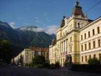 |
Looking down a street in downtown Inssbruck with the Alps in the background. |
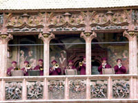 |
A live horn ensemble plays to passersby from the balcony of the Goldenes Dachl where Emperor Maximilian used to observe street performers. |
Lienz and Nationalpark Hohe Tauern
Lienz is the largest town
near the Austrian National Park, Hohe Tauern. Within the park is the
3797 M / 12,457 ft Grossglockner, Austria's highest mountain. Buses from
Lienz to the park are infrequent, and the ride is an hour. By the time
we reached the park, it was 11:00. The last bus returned at 16:30. We
selected a tough 12 km hike. It didn't happen. 3.5 km into the hike, we
got behind schedule and started to jog. Masami's leg told her to stop -
her shoe stuck between 2 rocks, her knee crashed onto a protrusion -
blood and pain. It was a slow return to our starting point. Wes carried
her down some of the steep sections. And on top of it all, we got snowed
on.
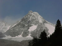 |
The top of Grossglockner was visible for a short time as clouds came and went. At times we had snow. |
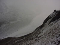 |
The glacier (behind the fog in the center of the picture) coming down from Grossglockner was barely visible. |
Copyright © 2000-2002 Wes and Masami Heiser. All rights reserved.